Eng-Tips is the largest forum for Engineering Professionals on the Internet.

Members share and learn making Eng-Tips Forums the best source of engineering information on the Internet!

  • Congratulations JStephen on being selected by the Eng-Tips community for having the most helpful posts in the forums last week. Way to Go!

AA jet and Military helicopter collide over Potomac 10

Is it just also a change of altitude max?
 
It could be the line thru the triangles indicate beginning/ending of Altitude transitions at those holding points?

If so, it seems required that this symbol is defined on the chart/map.

Edit: Altitude changeover point is the line. It is shown on legend above as a seperate line crossing route. So they combined the two symbols into two unique composite symbols.

In my world this is still a configuration management error, and leaves interpretation to each pilot of undefined composite symbols.

Captain Steerve says all on Army PAT pilot for his sucking radio BS.

 
Last edited:
Is there anything about legal action by the pax relative's?

I suspect making it too expensive will be the only way to stop it.
 
There will most likely be a class action. Class action protects the involved party from any future litigation. Two things must happen. The guilty have to agree on what they're willing to pay and the law firm has to accept 30% of that number. The victims will get what they get.
 
Well it seems that the root cause is a government agency of some flavour.

I suppose they could try and nail it on the air traffic controller.

The video above by the retired pilot from the squadron portrays what I would say is normal operations for dealing with this sort of thing.

They have similar in London with city airport and helicopter routes along the Thames. Funny enough I believe the Royal Family tended to move by road when possible and avoided helicopters. I susepct because a lot of the "dads" in the family are meant to be extremely knowledgeable and competent flying helicopters.
 
Capt Steeve failed to emphasize the route deviation.

This video shows PAT23 leaving helicopter route 5, and circling east around Pentagon and back west to Helicopter Pad at Pentagon, rather than following route 5 on the east side of Pentagon to North Landing Pad.

Army claims pilot was following Army Pentagon ATC instructions, which points finger at Army either way. Army Pentagon ATC and Helo pilot should both know not to deviate from helicopter route in this critical air space.

My thoughts are time to delete the Pentagon Route just North of DCA, as it has similar issues to closed route 5, and conflicts with 33 if plane has to do touch and go landing on 33 from the SE.

Captain Steeeve did show that PAT23 appeared to turn off transponder before landing, thus DCA ATC had no idea where chopper was


This is the official video and transcripts from the NTSB for the collision.

Helicopter pilot never got below about 240ft and the end is pretty chilling.

 
Thanks for video, however I don't see any transcripts in your posts?
 
Thanks for video, however I don't see any transcripts in your posts?
I meant that the presentation has the transcript of the pilots AND the internal cockpit conversation inside the helicopter.

The bit they didn't show coming to think about it was the vackground collision warning notification that came up on the ATC screens. I suspect that that controller will get hung out to dry for ignoring it and giving the helicopter approval to continue within one second of them asking. This was a training flight.
 
Whats the likelihood of them being forced into doing it?

Police will be an issues as well.
 
This People mag story appears to indicate everything was calm in helicopter - like the pilot and instructor were confident they were clear of the passenger jet. Seems to me they were not looking at the passenger jet or misinterpreted the distant or direction of travel.

 
Last edited:
The flight profile shows Helo Pilot was flying 'Cowboy', with rapid ups and downs, and Col for Army at NTSB hearing said there were no evasive maneuvers as part of the flight mission.

So clearly this is on FAA for setting up this designed to fail POS routes. But Pilot was not following flight route restrictions.

But the biggie is the testimony by the emergency services Medivac manager, and the Army saying they had always been told to hold at Haines point when traveling south and air traffic was landing or taking off.

Clearly the air traffic controlled failed horribly in his job by not holding helo, till traffic cleared.

NTSB was doing a great job in portion of todays event that I watched. It is clear that FAA and Army are not furnishing the information in a timely and open transparent manner. But from what I watched the FAA takes the PRIZE as being the worst managed and trying to cover it up........

Also it began evident that neither the Army or the FAA had clear memo's of agreement that fully defined every thing. Rather it was the 'Wild Wild West' .......fiying in or out of DCA, and a roll of the dice if your number came up
 
Last edited:
Early on they published that IP informed PF that they were at 300' when PF thought 200'. They never discussed discreapancy between altimeters, but PF would have known there was 100' discreapancy between her altimeter and IPs, and the smart play would have bern to drop altitude based on IP's altimeter, or go into holding pattern to sort it out.

As such, I don't see how it can be stated altimeter error is root cause.
 
I just again went over this new animation, and found nothing indicating the PF thought they were at 200'. And, if that was so, that it was based on an altimeter reading.

I do agree that the PF knew that the altitude was SUPPOSED to be below 200', though. Wanting something to be true does not translate to the fact.

I am surprised that the IP did not note that HIS altimeter continued to show the aircraft as being too high, after the earlier statement. I wonder if it was because he was going to note the failure after the completion of the check flight.

I wonder if the IP didn't assume the plane was using runway 1, which likely would have left them safe in their route. And also wouldn't need as much close observational awareness. I assume IP was very familiar with flying the route.
 
Last edited:
The conversation between PF and IP I was referring to may have been from before NTSB video timeline, or from an invalid source early on and now worth chasing; now that we know most Army altimeters don't read accurate, it would appear PF and IP would not think it is a big deal to have a 100' difference between altimeters, thus no discussion required just fly by eyes and average the two altimeter readings?

And all that says WHY was FAA allowing training missions with night vision under the landing and take off paths in the first place?

The summary, linked below, from NTSB hearings, spreads blame across everybody involved.

Routes were designed to fail, and Army was doing training missions during peak times at DCA, and with night vision goggles too.

They note in 2022 that PF failed a night vision check ride, and an instructor said PF was not a top gun. Route clearances were designed tighter than tolerances on altimeters, and that the Army did not ensure calibrations. They found some plus or minus 200 feet!


Ok here is where the IP and PF conversation was stated by NTSB.

"About three minutes before the crash, Eaves told Lobach to “come down for me” and fly at 200 feet because they were at 300 feet, the presentation revealed."
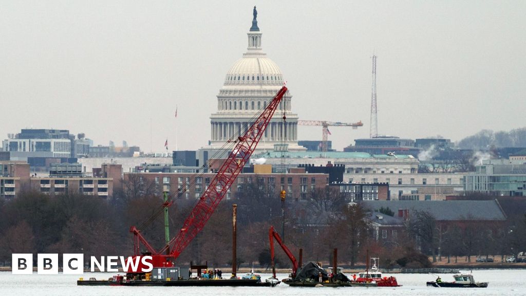
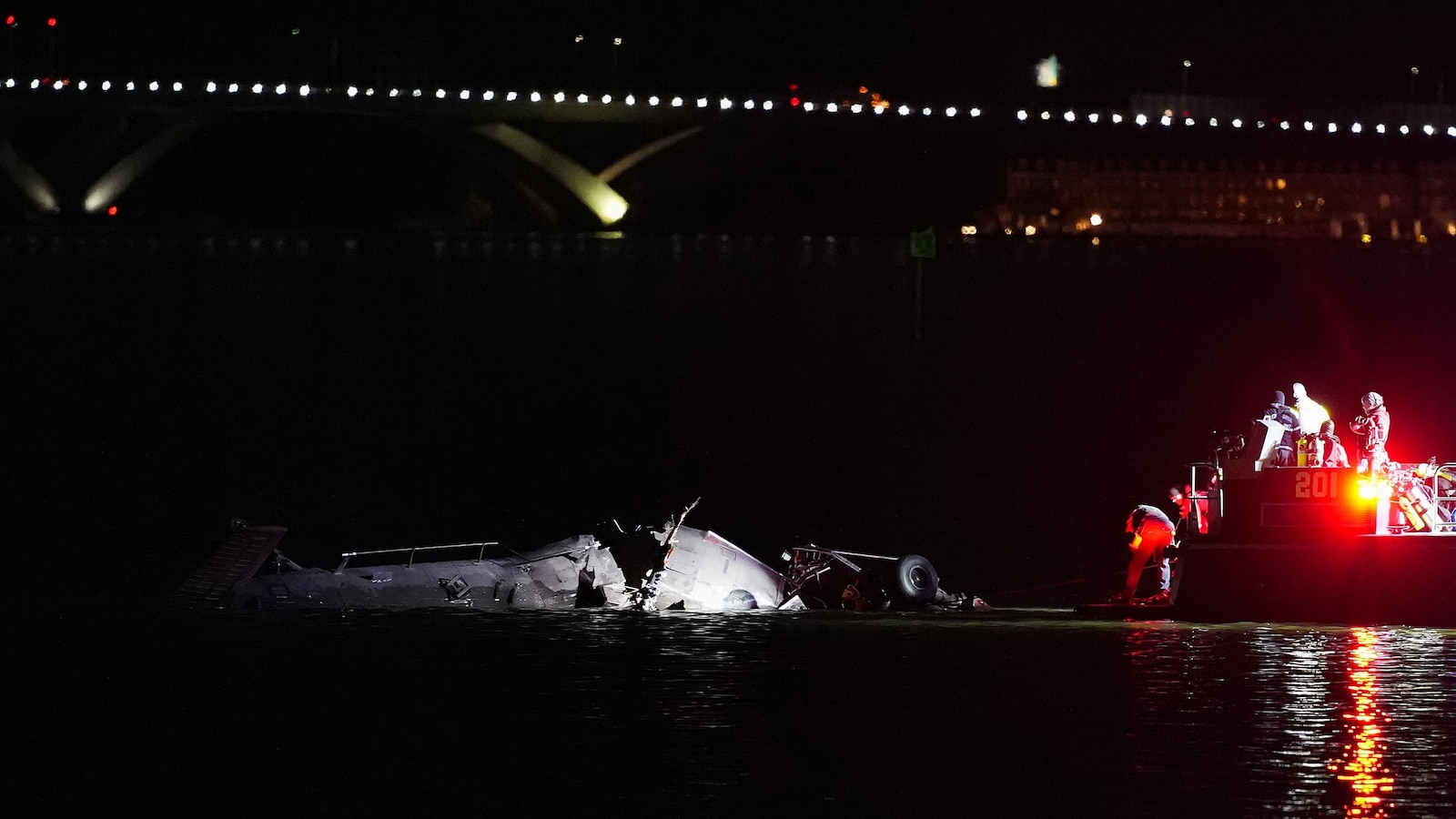

So PF and IP knew their was 100' difference in altimeters.

The NTSB recommended that the FAA require ADS-B on all aircraft as long ago as 2008.

Screenshot 2025-07-31 at 12.06.43 PM.png
yet this excerpt is not exact conversation language I remember?
 
Last edited:
"The conversation between PF and IP I was referring to, was prior to the transcript timeline in the video, as I remember."

The end of the conversation (I believe) is the PF saying "two hundred", 5 seconds before the timeline starts (and this was 28 seconds after the IP said "alright there's three hundred for two hundred"). At the beginning of the timeline, the altitude is 210'. THIS kinda implies the PF's altimeter was working--called 200' at 210'. That was before Memorial Bridge, where max height was 300'. But the craft immediately began rising to the high 300's by the time it got to the bridge, and the new 200' ceiling. Why would the PF go from the intended height of 200', up to about 400'? Especially since the REQUIRED 200' section was coming up soon.

To me, that suggests strongly that the PF was not paying attention to the altimeter. That would be the altimeter that was closely matched about 30 seconds earlier. And it suggests to me that the PF was not comfortable enough flying to pay closer attention to the altimeter. Or be able to keep the height automatically.

And I am sure the IP did not feel in danger while not commenting on this, and allowing the error to continue for the rest of the flight. Because they still would have missed the plane if it was landing or runway 1.


spsalso
 
I think you are right the PF was not comfortable on the test ride with the night vision googles on, and had previously failed night vision certification in 2022. Thus looking out of corner of googles to see altimeter was an issue for PF. Clearly if IP thought it was runway 1 landing, and not 33 then he was very comfortable with current situation, no matter the irregular altitude.

IP was on right side of chopper, and left side was PF's responsibility, and if she was not looking at altimeter then doubtful she has her head on a swivel looking left?

At the NTSB hearing an Army Pilot stated most missions only require maintaining altitude within a 100', as I remember hearing.

Again should NOT be training green pilots in a civilian air space under the landing and takeoff flight paths which is on FAA and Army both. But in reality we all know it was Politicians probably making the decisions and dumping downward.............
 

Part and Inventory Search

Sponsor

Back
Top