Continue to Site

Eng-Tips is the largest engineering community on the Internet

Intelligent Work Forums for Engineering Professionals

  • Congratulations cowski on being selected by the Eng-Tips community for having the most helpful posts in the forums last week. Way to Go!

Are the contours on ASCE 7-10 maps defined precisely anywhere? 6

Status
Not open for further replies.

Petras Surna

Structural
Jan 9, 2017
7
[tt]I am looking for an electronic definition of the maps in ASCE 7-10 for wind and snow.

The ideal solution would be a Google map that has the contours drawn as custom lines.

If that existed, I could get a definition of the contours as a list of latitude and longitude coordinates, put them in a database and find the
wind speed at any location by some programming.

As it stands, I am going to have to create these maps, which is a messy, time-consuming task.
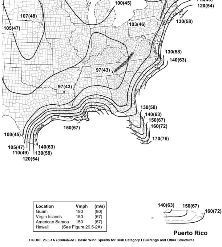
lat-long_guaorl.jpg


[/tt]
 
Replies continue below

Recommended for you

Petras Surna:
I wouldn’t spend a lot of time programming exactly for latitude and longitude, since those contour lines are probably not accurate/definitive to much more than +/- 5mm anyway (ya think?). Sometimes a little engineering experience and judgement are required in pretending to be a real engineer, not just a bigger, better, more expensive program. Furthermore, most local AHJ, States, Counties, etc. might have made minor adjustments to meet their own experience or local stds. and customary practice. If you work in the region, you probably know the local stds. and requirements, if not ask the local AHJ.
 
I agree with dhengr, those maps are most likely not as accurate as your methodology would make them appear. To know the wind speed as accurate as you suggest, they would have to have thousands of accurate wind speed recorders that I am pretty sure they do not have. At best you are going to save 5 mph over the current system.

Also, I have used 2 different maps that did have latitude and longitude. There was a slight variance on the the values for a house I could zoom into on both maps and see. I could put my cursor over the roof on both. The difference in the values sometimes ran for several houses away.
 
I recently used the ASCE7 Hazard Tool to get ground snow loads for a project. Even though the project was a few miles away from the contour line (per the online tool) on the 50 psf side, the state website listed 60 psf for that town. I had designed the structure for 50 psf but the 60 psf requirement was pointed out by a contractor when the project was out to bid. Pretty embarrassing.
 
The seismic data you can pull via a web API request to USGS, see here for an example: LINK

The wind data isn't freely available the ATC website will give you access to their API, again handled via a web request but requires a license key to get a response from the API: LINK

Neither tool will capture local code requirements

For the wind tool I've seen the approach where the contour areas were traced with closed polygons and the image normalized to lat,long reference then using a point in polygon algorithm determine which contour polygon the specified location was in and report back the wind value.

My Personal Open Source Structural Applications:

Open Source Structural GitHub Group:
 
bones206, this seems to be a somewhat common mistake. It's always good practice to check local jurisdictions for modifications to ASCE7.

A couple years back another engineer did some preliminary design for a project that include a PEMB. They did some early estimating off that preliminary design. I took over the project and discovered the wind load was way wrong (this was a special wind region). I think the ultimate wind speed was 178 MPH and we originally called out something like 130 MPH. Ooooops.
 
We do work in odd ball municipalities all over and always check for local code amendments. CT state code specifies design criteria for each city. MA too maybe.

I hate when I find design criteria per a local amendment that still references a code that has been superseded. Usually a small town with 1 building official/inspector/plan reviewer.
 
If it's a common mistake, that usually means the system is flawed. If local jurisdictions publish amendments, why can't ASCE/IBC adopt them into the model code for consistency? The snow load list that bit me isn't even published as an official amendment. It's just some random pdf buried on the state website that you wouldn't know to look for.
 
I can't imagine expecting ASCE/IBC to incorporate what likely amounts to thousands of local amendments into the model code. A little bit of research up front goes a long way towards getting the loading right. A random one-off thing like bones describes is rare from my experience and is a problem. The local engineers likely know about it but in today's world all engineers won't be local.

Like azcats I'm doing work all over and the first thing I do is research the AHJ and see if I can find amendments online. If I can't I make a phone call that I document.
 
I agree that adding local amendments in print-form would be impractical. But it could easily be included in the database that the online hazard tools use.
 
The database is handled by scientists and researchers actively using the data.
AHJ amendments are made by local elected officials for numerous and sometimes odd reasons that don't necessarily have a statistical or scientific basis. The amendment maybe put on the AHJ website by the unpaid intern or just live in a hard copy file of the meeting minutes.

I agree the process is garbage in it's current form but I really don't ever expect it to change as there is a fundamental disconnect between the two.

My Personal Open Source Structural Applications:

Open Source Structural GitHub Group:
 
Status
Not open for further replies.

Part and Inventory Search

Sponsor