I finally figured out what the "hole" is. To figure it out I had to
compare several days of video and pictures.
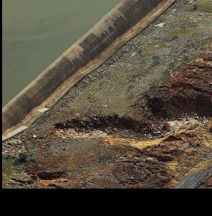
On Saturday (11th) pictures you can see the road that cuts down slightly diagonally to the E-spillway.
That road runs across the entire E-spillway and then back up around to the recreational area.
That road was on a berm to get it level, well not dippy, it had slope. That berm created what is being called
a "catch basin". That basin filled up a couple of hours after the E-spill started. It didn't fill as quickly
as one would've guessed because the whole E-spill was in operation and most of the water wandered downhill
using many different paths.
But fill it inevitably did. Once it filled the rec-road became a secondary spillway. Being sloped though got
some concentrated flow on it and it quickly failed in it's short spillway life. Once the pavement left the
entire berm vacated in a very short time probably around an hour. This translated the "catch-basin" into a
shockingly large "hole" as the people onsite watched. Since this large hole is fairly close to the E-spill
it now gathers the lion's share of all the spill. Of course this focuses the erosion in the hole. At that
point the officials believed the erosion was progressing rapidly back towards the E-spill wall. The reality is
it was probably not as fast as they thought but more of a story allusion fed by the rapid transformation from
catch-basin to hole.
Anyway, the decision to really crank-up the primary-spillway was probably the best idea.
The helicopter rock bag delivery is to fill that "hole".
Keith Cress
kcress -
")