Continue to Site

Eng-Tips is the largest engineering community on the Internet

Intelligent Work Forums for Engineering Professionals

  • Congratulations KootK on being selected by the Eng-Tips community for having the most helpful posts in the forums last week. Way to Go!

Estimation of Lateral Stretch in CLiq

Status
Not open for further replies.

Greenalleycat

Structural
Jul 12, 2021
508
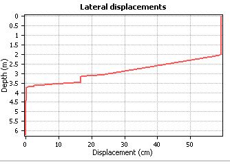
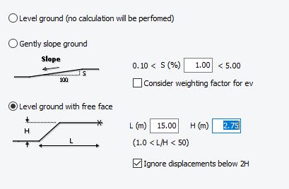
I am assessing the liquefaction susceptibility of several sites based off CPT data. The edge of the site has a drainage swale approximately 2.75m from top to bottom and evenly battered over about 8.2m horizontally (i.e. ~18 degree flat slope). The groundwater table seems to hover around 2.5-3m in my testing on the site, but I have adopted 2m in my analysis as other testing nearby found a shallower watertable. CLiq is giving me moderate vertical settlements of ~35mm - seems reasonable. However, it is predicting lateral displacements of 600mm to 1200mm across my various sites. I have attached my inputs and one of the lateral displacement profiles as a reference.

I find it extremely difficult to believe that there will be over 1.2m of displacement (in some instances). Does anyone have experience with this and can offer some insight as to how to interpret this data? I have done a lot of reading on the topic and it seems widely accepted that lateral stretch is a bit of a guesstimate and that these calculations can have significant error of 2x or more, but that still doesn't really help. Even a 3x error leaves me with estimates of 200mm to 400mm.

lateral_jumxdh.jpg
input_yjxudm.jpg
 
Replies continue below

Recommended for you

Lateral spreading, not lateral stretch

Under the right conditions, of free face height, thickness of liquefiable layer and EQ parameters you can get very high lateral spreading. 18 degree is a moderately steep slope, which I would probably do a slope stability analysis for.

I would definitely think you could get very large displacement. I agree that 1.2m seems excessive, but still anything over a say 300mm is a very high risk and needs some sort of treatment. I definitely think you could get 300mm

 
Yes good point, I have butchered my terminology. The lateral displacement is estimated at max 1.2m, the lateral stretch estimates are about half of that (estimating front and back locations for an imaginary house).

Something that confuses me is that a significant portion of the displacement occurs below the bottom of the swale... Given that this level is effectively an infinite plane of sand, how does this manifest?
 
how can you determine that a significant portion of the displacement occurs beneath the swale? From my dealing with CLIQ, you analyze a CPT that you consider to be representative. The resulting displacement is the magnitude of displacement that can occur under the Length considered?

Doesnt tell you where it occurs, or are you considering several CPTs. Sorry maybe I am missing something?
 
I've heard lateral stretch, lateral strain, lateral spreading, 'lateral ground movement', and lateral displacement all used to refer to this concept so personally I wouldn't be to fussed about the terminology, I don't think that their is a 'correct' terminology at this stage. The CLIQ manual refers to it as lateral displacement, Peter Robertson I believe uses both 'Lateral Displacement' and 'Lateral Spreading Displacement', and Cubrinovski also uses various of the above terms.

Regarding the groundwater table, personally I think it's a bit of double jeopardy to assume worst-case groundwater conditions at the same time as an earthquake. In particular since it seems like your lateral spread is occurring into a drainage feature which except during extreme events is probably keeping the groundwater down to that 2.5-2.75m range.
 
@EireChch, in short, I have taken a representative CPT (3 of them, in fact) that I arranged to be undertaken close to a likely lateral spread hazard (the swale). CLiq calculates incremental shear strains from the CPT data input and integrate them over depth to give a summation of lateral displacement with depth - this is one of the plots I attached.

@geotechguy1, you're right, it is likely quite harsh. I have also run the case of the groundwater table at 2.75m i.e. the swale depth. This reduces the displacements by a lot, but they are still on the order of several hundred millimetres. As would be expected, CLiq shows the displacement all occurring below the bottom of the swale - there is a highly liquefiable layer down to about 4.5m. However, this brings me back to my previous question... given that the level below the swale is effectively an infinite plane of sand, how does this displacement manifest? My sites are built up above the adjacent ground, so the swale is actually more like a step down to the primary ground level in the area.
 
Hey Greenalleycat - I am by no means an expert on this topic but I believe that what CLIQ is telling you is that the layer from 2 - 3.75m would liquefy, and then lateral displacement can occur within the liquefied layer, and also on the soil above the liquefied layer, which is moving along on the liquefied layer. So while your sand layer below the swale may be infinite if it liquefies that isn't doing anything to stop the lateral displacement (I'm assuming you're thinking the infinite extent of the sand layer would stop lateral movement - but it can't if it liquefies). There are a couple of figures in the below linked paper that might shed some light on it.


Also I agree with EireChch that it seems like high risk...these methods are kind of a ballpark estimate even by geotechnical standards, it's more like the software is just telling you that you have a problem. The Robertson / Zhang paper suggests that if you calculate a meter of displacement it means you might be in the range of 0.5m - 2.0m based on the data they had.
 
Appreciate the input mate. I think my takeaway is that, most likely, the water table sits at or below the level of my 'features of concern' such as the swale. Thus, though highly likely to liquefy, I imagine that the most likely failure mechanism is more of a global movement of my site above the liquefied ground (crust over goop), rather than a significant liquefied slope failure.
 
Status
Not open for further replies.

Part and Inventory Search

Sponsor