×
INTELLIGENT WORK FORUMS
FOR ENGINEERING PROFESSIONALS

Contact US

Log In

Come Join Us!

Are you an
Engineering professional?
Join Eng-Tips Forums!
  • Talk With Other Members
  • Be Notified Of Responses
    To Your Posts
  • Keyword Search
  • One-Click Access To Your
    Favorite Forums
  • Automated Signatures
    On Your Posts
  • Best Of All, It's Free!

*Eng-Tips's functionality depends on members receiving e-mail. By joining you are opting in to receive e-mail.

Posting Guidelines

Promoting, selling, recruiting, coursework and thesis posting is forbidden.

Students Click Here

Snow Load Calculator
4

Snow Load Calculator

Snow Load Calculator

3
(OP)
Finally finished up the snow load calculator. Moved it to this page:

http://design.medeek.com/resources/snow/snow_calculator.pl

Give it a whirl and let me know what you think.

I wish there was an easy way to calculate the ground snow loads for a given location but unfortunately there is not.

RE: Snow Load Calculator

Very nice, medeek. Thank you!

Best to you,

Goober Dave

Haven't see the forum policies? Do so now: Forum Policies

RE: Snow Load Calculator

(OP)
I've recently spent some time looking at the snow load requirements of the ASCE 7-10 and the various state modifications to the IBC and IRC. Obviously this is a gargantuan task, to summarize all this data and present it in a usable fashion. I have managed to chip away at a few states that have standardized snow load data or equations. The latest state I've tabulated is New York State:

http://design.medeek.com/resources/snow/newyorkgro...

My map of the ASCE 7-10 ground snow loads is still unfinished, not because I cannot finish it but because I am currently waiting on a response back from the ASCE licensing division about the reproduction of the data presented in Fig. 7-1 (ground snow load map). Reproducing or displaying a scanned version of the map seems to be less of a concern that creating an accurate electronic version of the map that is much more useful to the general public and engineering community.

I am summarizing each States snow load requirements on this page:

http://design.medeek.com/resources/snow/statesnowl...

As you can see I've only just started. Some states such as Colorado let the local jurisdictions (City and County) set their own snow load requirements so creating a map for the entire state is more difficult but not necessarily impossible. Some states such as Oregon have developed much more sophisticated online systems, I applaud their efforts.

RE: Snow Load Calculator

@medeek>>> Thanks for posting.

RE: Snow Load Calculator

(OP)
Oregon Snow Load map is up. This one, like the Montana Map, connects to the snow load database hosted by the SEAO. It also compares the retrieved value against the 20 psf snow load minimum as well as checks the modeled elevation against the actual site elevation and flags the user based on these checks.

The advantage to using this tool is that you don't need to know the lat. and long. off hand, just click on the map and it does the rest.

http://design.medeek.com/resources/s...snowloads.h...

Also added in "tile" surface to the calculator per request from a southern California resident, not that they get much snow down there.

RE: Snow Load Calculator

(OP)
Just completed the Ground Snow Load Map tonight.

http://design.medeek.com/resources/snow/groundsnow...

Digitizing it, so that it was accurate, took far longer than I had planned on but once I was underway I wasn't about to stop.

Note how most of the western US requires case studies, hence many of these states have their own snow load maps and research to back them up.

RE: Snow Load Calculator

(OP)
Interestingly I had a company that manufacturers and installs solar panels contact me regarding the ASCE ground snow load map. They were wondering if there was a way so that their website could send an http request to the map with a latitude and longitude and have it kick back the snow load. Since the map is already in digital format you would not think this would be hard to do. So I got thinking about how I could build a program that given a certain lat and long would automatically click on the map and then fire back the elevation, snow load, etc...

The only problem is google maps implementation of the KML layer does not allow this transmittal of information. So I basically banged my head against the wall for almost 2 weeks trying to do the impossible. However, I was not ready to throw in the towel just yet. Since the KML data is just plain text, (coordinates) I thought there must be some way to analyze this data and determine if a given location is within a certain polygon and if it is then be able to assign that polygon description (ASCE snow load details) to a variable which is then delivered to the client. Turns out this is called the point in the polygon problem and it is well documented:

http://en.wikipedia.org/wiki/Point_in_polygon

So I was about to write an algorithm for ray casting which would have taken some time. Then I thought maybe someone else has done this before and sure enough I found a couple of good perl modules that handled this nicely and I narrowly avoided reinventing the wheel. Just a few lines of Perl later and I had managed to create a nice little API for the ASCE ground snow load data:

http://design.medeek.com/resources/medeekapi.html

RE: Snow Load Calculator

(OP)
Added seismic and wind data to API

RE: Snow Load Calculator

(OP)
Michigan Ground Snow Loads map is now up.

http://design.medeek.com/resources/snow/michigangroundsnowloads.html

This zone map is essentially an approximation of the ASCE snow load map with isolines fitted to county and township boundaries.

I'm not entirely satisfied with the appearance of this map since the county lines make the map appear too busy.

RE: Snow Load Calculator

(OP)
Vermont Ground Snow Loads Map is now complete:

http://design.medeek.com/resources/snow/vermontgroundsnowloads.html

This zone map defines ground snow loads by township and city boundaries and is derived from the zone map on page 48 of the 2012 Vermont Fire & Building Safety Code.

Vermont is a small state so the KML for this map was relatively easy to create.

RE: Snow Load Calculator

(OP)
I began working on the idaho snow load map based on the the snow load study by Dr. Ronald L. Sack done in 1986 and published by the University of Idaho. It has taken nearly three days to digitize the isolines to sufficient enough accuracy so that the normalized ground snow loads can be calculated. Other than the national snow load map this is probably my most ambitious project to date. I am now converting the KML polygons shown here:

Idaho Ground Snow Loads

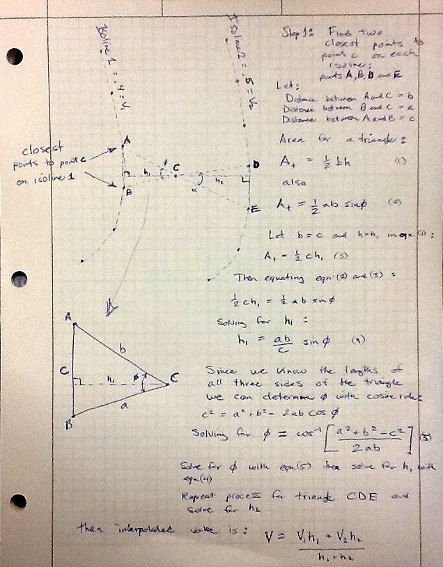
into KML paths (isolines). The tricky part will be programming the algorithm that can interpolate between isolines. The basis for this algorithm is my previous study shown below.


The interpolation is further complicated with peaks, valleys, ridges and saddle points. In order to deal with these degenerate cases will require the addition of some virtual isolines to provide additional data points to the algorithm.

When I am finished the user should be able to click on the site location on the map and get an accurate NGSL which then automatically multiplied by the site elevation will give the ground snow load for that location.

RE: Snow Load Calculator

(OP)
The map is all there now, zone and isolines. Now I am trying to figure out the interpolation algorithms. For the linear interpolation between regular isolines the following equation holds:

V = (V2h2 + V1h2)/(h1 + h2)

For the interpolation at the peaks and valleys I've decided to use a non-linear method to better approximate what I would expect in reality. This equation I've derived as:

V = (6V2h2 + .5V1h22)/(6h1 + .5h22)

RE: Snow Load Calculator

(OP)
It would be nice if one could edit these post for typos. The first h2 in the numerator of both expressions should be h1.

RE: Snow Load Calculator

(OP)
The interpolation seems to be working. The detailed report is still under construction but give the app a try and tell me what you think:

Idaho Ground Snow Loads

RE: Snow Load Calculator

(OP)
The snow load calculator has now been upgraded with a PDF report output, which is really nice for printing out hard copies.

http://design.medeek.com/resources/snow/snow_calcu...

It was a real pain to format this document from HTML to PDF. However, I will probably do the same PDF report format for the wind, seismic and ground snow load maps as I get time.

RE: Snow Load Calculator

(OP)
I've added the PDF report option to the ASCE Ground Snow Load Map, give it a shot and tell me what you think. I think the output is more complete than the interactive map since I'm also doing a reverse geocode on the lat/long however the downside is the KML layer can't be overlaid on the static maps shown in the PDF document.

http://design.medeek.com/resources/snow/groundsnow...

Red Flag This Post

Please let us know here why this post is inappropriate. Reasons such as off-topic, duplicates, flames, illegal, vulgar, or students posting their homework.

Red Flag Submitted

Thank you for helping keep Eng-Tips Forums free from inappropriate posts.
The Eng-Tips staff will check this out and take appropriate action.

Reply To This Thread

Posting in the Eng-Tips forums is a member-only feature.

Click Here to join Eng-Tips and talk with other members! Already a Member? Login


Resources

Low-Volume Rapid Injection Molding With 3D Printed Molds
Learn methods and guidelines for using stereolithography (SLA) 3D printed molds in the injection molding process to lower costs and lead time. Discover how this hybrid manufacturing process enables on-demand mold fabrication to quickly produce small batches of thermoplastic parts. Download Now
Design for Additive Manufacturing (DfAM)
Examine how the principles of DfAM upend many of the long-standing rules around manufacturability - allowing engineers and designers to place a part’s function at the center of their design considerations. Download Now
Taking Control of Engineering Documents
This ebook covers tips for creating and managing workflows, security best practices and protection of intellectual property, Cloud vs. on-premise software solutions, CAD file management, compliance, and more. Download Now

Close Box

Join Eng-Tips® Today!

Join your peers on the Internet's largest technical engineering professional community.
It's easy to join and it's free.

Here's Why Members Love Eng-Tips Forums:

Register now while it's still free!

Already a member? Close this window and log in.

Join Us             Close